Singapore Geoid Model 2009 (SGEOID09)
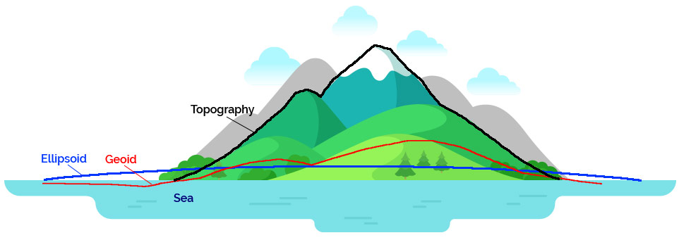
There is a degree of difficulty in relating GPS heights obtained from Global Positioning System (GPS) surveying to the existing national leveling networks in most countries where GPS survey is used alongside traditional survey methods. Heights provided by GPS relate to the surface of an ellipsoid, which approximates the shape of the earth, but does not coincide with the geoid. GPS can only be used in most countries to measure the heights meaningfully only above a reference datum if the relationship between the ellipsoid and the geoid is established.
Vertical Datum
The vertical datum is the reference used for high precision height positioning measurement. To realise this vertical datum, ground points with known height values referenced to the vertical datum are established in many countries.
In Singapore, the official Singapore's vertical reference datum used for cadastral surveys is the Singapore Height Datum, which can be referenced using Singapore's network of control points, individually known as Precise Levelling Benchmarks (PLBMs).
In order to achieve consistency for all height positioning activities on land in Singapore and to be aligned with Singapore Height Datum, all levelling surveys should be linked to PLBMs that are aligned to the Singapore's official height datum.
Height Obtained From Precise Levelling vs GPS
With the increasing use of GPS in positioning activities, it is now possible to obtain surface planar coordinates (X and Y) as well as a GPS height (Z). However, the height coordinate from GPS is referenced to a mathematical model known as an ellipsoid.
Note that a GPS receiver on a ship at sea level (tides not considered) during the course of a long voyage, may indicate height variations, This is because GPS satellites can only measure heights relative to a geocentric reference ellipsoid as they orbit about the center of gravity of the Earth. As a result, GPS height must be corrected to obtain geoidal height while in traditional leveling, the height obtained will always be geoidal height.
About SGEOID09
A Geoid is a model of the equipotential surface of the earth's gravity field that is best approximated by the mean sea level over the oceans which extends hypothetically beneath all land surfaces (DMA, 1997)
SGEOID09 is the geoid model for Singapore. A good geoid model allows us to determine geoidal heights using Global Navigation Satellite System (GNSS) (which yields ellipsoid height).
Applications of SGEOID09
Geoid model can be used for applications where precise real-time measurement of height is required. These applications include:
-

Engineering
Surveys -

Vertical Deformation
Monitoring -

Asset
Tracking -

Coastal
Monitoring
Some actual uses of Geoid Models in the world are:
- Engineering deformation monitoring for reservoir embankment
- 3-dimensional coordinates for stations of the London Water Ring Main project (Dodson, 1995)
SGEOID09 Calculator
This function allows you to perform conversion of Ellipsoidal height to reduced level height for Survey Department's datum. *
To specify SVY21 Coordinates and WGS84 Ellipsoidal height.
I am ready!
Subscribe to SiReNT


If you are registering for an account on behalf of your company, you must use the company's CorpPass account
Disclaimer: Use of SGEOID09 Service
The SGEOID09 Service is provided by SLA free to users for converting ellipsoidal height obtained in the SVY21 coordinate system to a height value reference to Survey Departments Datum. The user has the sole and complete responsibility to assess whether this service is suitable for the purpose which is intended and decide whether the results obtained from this service could be used for his purpose. The service is only valid for use with coordinates within mainland Singapore.
SLA
- does not represent or intend for this service to be used as a replacement for Precise Leveling Bench Mark information;
- shall not be bound by any information in the SGEOID09 Service and does not make any representations or warranties whatsoever as to the accuracy, reliability, completeness or adequacy of any of the information contained in this web page;
- does not represent or intend for this service to be used for cadastral and/or hydrographic surveys. This Service is not to be used to derive precise heights or in applications which require precise heights and the user must verify the result obtained using established surveying methods.
- may, at its absolute discretion, at any time and from time to time, modify or suspend the SiReNT Service, without any prior notice, whether for the purposes of website updating and upgrading or system maintenance or otherwise. SLA shall not be liable to the Registered User or any third party for any such modification or suspension of the SiReNT Service
- retains all title to and Intellectual Property Rights in the Data which are owned by and shall at all times remain with SLA. All rights in the Data whether existing at the Commencement Date or which may come into existence thereafter which are not specifically granted to the User under these General T&Cs are expressly reserved to SLA.
By using the SGEOID09 Service, you
- understand the suitability of the service for your purpose, and acknowledge that the use of the service is at your own risk and that SLA does not any responsibility for any degree of direct or indirect consequences resulting from your use of the service. You accept such risks and will not hold SLA liable for any damage or loss whatsoever including but not limited to direct, indirect, punitive, special or consequential damages, arising directly or indirectly as a result of your use or reliance on any information from the SGEOID09 Service;
- acknowledge and agree that any deletion, addition, adjustment, alteration, adaptation or modification of the Website Pages, Contents or Data is a violation of Intellectual Property Rights subsisting therein owned by SLA or SLA's third party suppliers. You will not make or attempt to make any deletions, additions, adjustments, alterations, adaptations or modifications to the Website Pages, Contents.
-
shall not, except as expressly authorised by General T&Cs:
- use the SGEOID09 Service for any purpose or for any commercial use whatsoever, in Singapore or elsewhere,; or
- make any reproduction of the Website Pages, the Contents or the Data, in whole or in part; or
- create any products or services directly or indirectly from or through the use of the Website Pages, the Contents or the Data; or
- sell, rent, lease, sub-license, lend, time share or transfer the Website Pages, the Contents or the Data or in any other way whatsoever commercially exploit the Contents or the Data; or
- remove, alter or obscure any copyright or other proprietary notices on the Website Pages, the Contents or the Data; or
- represent or in any way hold out the Website Pages, Contents or the Data as the property of or in the ownership of the Registered User or of any party other than SLA; or
- use the Website Pages, the Contents or the Data as a collateral, pledge, deposit or any other form of security whatsoever; or
- publish or make available the whole or any part of the Website Pages, the Contents or the Data by electronic, mechanical or any other means, in Singapore or elsewhere; or
- deal with the Website Pages, Contents or the Data, in any other manner whatsoever without SLA's prior written consent.