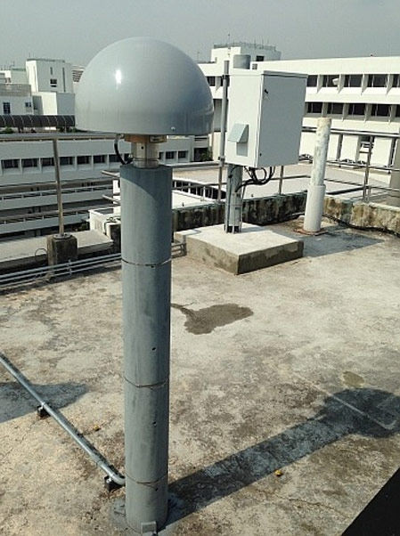
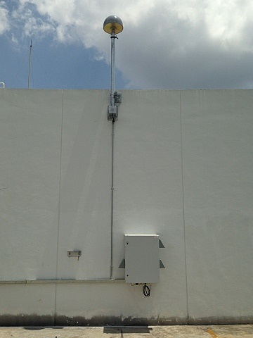
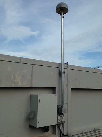
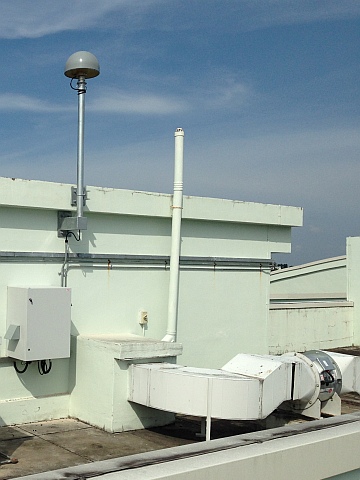
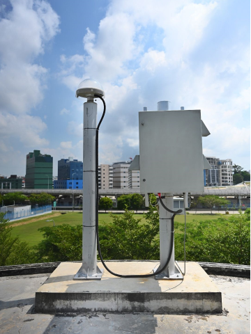
Reference Stations
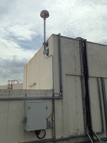
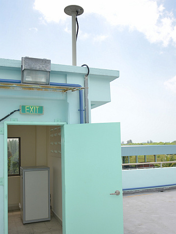
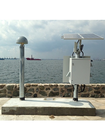
SiReNT currently includes nine reference stations that provide coverage of mainland Singapore as well as the offshore islands in the provision of differential GNSS correction data. Each reference station is installed in secured locations and we actively maintain them to ensure optimal operations. Aside from the SING reference station which is used as an integrity monitoring reference station for the network, the other nine stations are available for users to connect to.
Sensor Map (9 Locations)
Select reference station to view more information.
| Station ID | SNYU | ||
|---|---|---|---|
| Location | Nanyang Technological University (NTU) | ||
| Coordinates (WGS-84) | Latitude | N 1°20'44.84810" | X -1508025.227 m |
| Longitude | E 103°40'47.91672" | Y 6195576.969 m | |
| Ellipsoidal Ht | 76.246 m | Z 148798.263 m | |
| Coordinates (SVY21) | Easting | Northing | |
| 10934.735 m | 36436.799 m | ||
| GNSS Receiver | Trimble Alloy | ||
| GNSS Antenna | Trimble GNSS-Ti Choke w/SCIS Dome | ||
| IGS Code | TRM59900.00 SCIS | ||
| Antenna Height | 0.000 m | ||
| Measured up to | Bottom of antenna mount | ||
| Antenna Installed on | 2014 | ||
| Information Last Updated | 5 May 2015 | ||
| Station ID | SRPT | ||
|---|---|---|---|
| Location | Republic Polytechnic | ||
| Coordinates (WGS-84) | Latitude | N 1°26'37.41926" | X -1519248.959 m |
| Longitude | E 103°47'03.88829" | Y 6192545.559 m | |
| Ellipsoidal Ht | 59.411 m | Z 159624.074 m | |
| Coordinates (SVY21) | Easting | Northing | |
| 22557.618 m | 47265.636 m | ||
| GNSS Receiver | Trimble Alloy | ||
| GNSS Antenna | Trimble GNSS-Ti Choke w/SCIS Dome | ||
| IGS Code | TRM59900.00 SCIS | ||
| Antenna Height | 0.000 m | ||
| Measured up to | Bottom of antenna mount | ||
| Antenna Installed on | 2014 | ||
| Information Last Updated | 5 May 2015 | ||
| Station ID | SNPT | ||
|---|---|---|---|
| Location | Nanyang Polytechnic | ||
| Coordinates (WGS-84) | Latitude | N 1°22'44.82064" | X -1526243.018 m |
| Longitude | E 103°50'55.51059" | Y 6191002.686 m | |
| Ellipsoidal Ht | 55.486 m | Z 152481.753 m | |
| Coordinates (SVY21) | Easting | Northing | |
| 29717.651 m | 40121.255 m | ||
| GNSS Receiver | Trimble Alloy | ||
| GNSS Antenna | Trimble GNSS-Ti Choke w/SCIS Dome | ||
| IGS Code | TRM59900.00 SCIS | ||
| Antenna Height | 0.000 m | ||
| Measured up to | Bottom of antenna mount | ||
| Antenna Installed on | 2014 | ||
| Information Last Updated | 5 May 2015 | ||
| Station ID | SLYG | ||
|---|---|---|---|
| Location | Loyang | ||
| Coordinates (WGS-84) | Latitude | N 1°22'21.44707" | X -1539524.135 m |
| Longitude | E 103°58'18.00928" | Y 6187726.731 m | |
| Ellipsoidal Ht | 51.158 m | Z 151763.925 m | |
| Coordinates (SVY21) | Easting | Northing | |
| 43396.751 m | 39403.770 m | ||
| GNSS Receiver | Trimble Alloy | ||
| GNSS Antenna | Trimble GNSS-Ti Choke w/SCIS Dome | ||
| IGS Code | TRM59900.00 SCIS | ||
| Antenna Height | 0.000 m | ||
| Measured up to | Bottom of antenna mount | ||
| Antenna Installed on | 2014 | ||
| Information Last Updated | 5 May 2015 | ||
| Station ID | SNSC | ||
|---|---|---|---|
| Location | National Sailing Centre | ||
| Coordinates (WGS-84) | Latitude | N 1°18'49.12095" | X -1538472.450 m |
| Longitude | E 103°57'42.01188" | Y 6188108.833 m | |
| Ellipsoidal Ht | 15.253 m | Z 145243.192 m | |
| Coordinates (SVY21) | Easting | Northing | |
| 42284.293 m | 32882.042 m | ||
| GNSS Receiver | Trimble Alloy | ||
| GNSS Antenna | Trimble GNSS-Ti Choke w/SCIS Dome | ||
| IGS Code | TRM59800.00 SCIT | ||
| Antenna Height | 0.000 m | ||
| Measured up to | Bottom of antenna mount | ||
| Antenna Installed on | 20 December 2011 | ||
| Information Last Updated | 5 May 2015 | ||
| Station ID | SNUS | ||
|---|---|---|---|
| Location | National University of Singapore | ||
| Coordinates (WGS-84) | Latitude | N 1°17'32.68755" | X -1518382.637 m |
| Longitude | E 103°46'31.83287" | Y 6193173.459 m | |
| Ellipsoidal Ht | 63.417 m | Z 142897.210 m | |
| Coordinates (SVY21) | Easting | Northing | |
| 21566.307 m | 30534.079 m | ||
| GNSS Receiver | Trimble Alloy | ||
| GNSS Antenna | Trimble GNSS-Ti Choke w/SCIS Dome | ||
| IGS Code | TRM59900.00 SCIS | ||
| Antenna Height | 0.000 m | ||
| Measured up to | Bottom of antenna mount | ||
| Antenna Installed on | 2014 | ||
| Information Last Updated | 5 May 2015 | ||
| Station ID | SSMK | ||
|---|---|---|---|
| Location | Semakau Landfill | ||
| Coordinates (WGS-84) | Latitude | N 1°12'37.48752" | X -1518410.730 m |
| Longitude | E 103°46'31.49934" | Y 6193331.346 m | |
| Ellipsoidal Ht | 25.419 m | Z 133831.345 m | |
| Coordinates (SVY21) | Easting | Northing | |
| 21555.796 m | 21466.939 m | ||
| GNSS Receiver | Trimble Alloy | ||
| GNSS Antenna | Trimble Zephyr Geodetic 2 | ||
| IGS Code | TRM55971.00 | ||
| Antenna Height | 0.000 m | ||
| Measured up to | Bottom of antenna mount | ||
| Antenna Installed on | 21 August 2009 | ||
| Information Last Updated | 5 May 2015 | ||
| Station ID | SSTS | ||
|---|---|---|---|
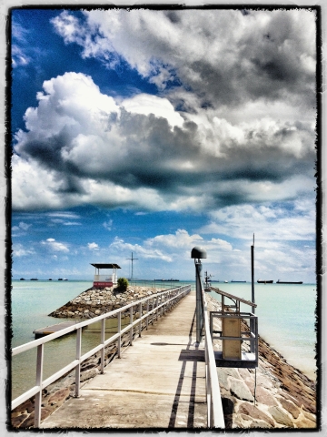
| Location | Sultan Shoal | ||
| Coordinates (WGS-84) | Latitude | N 1°14'23.49077" | X -1504599.629 m |
| Longitude | E 103°38'52.29482" | Y 6196617.251 m | |
| Ellipsoidal Ht | 13.570 m | Z 137086.270 m | |
| Coordinates (SVY21) | Easting | Northing | |
| 7359.574 m | 24723.506 m | ||
| GNSS Receiver | Trimble Alloy | ||
| GNSS Antenna | Trimble GNSS-Ti Choke w/SCIS Dome | ||
| IGS Code | TRM59900.00 SCIS | ||
| Antenna Height | 0.000 m | ||
| Measured up to | Bottom of antenna mount | ||
| Antenna Installed on | 2014 | ||
| Information Last Updated | 5 May 2015 | ||
| Station ID | SMS1 | ||
|---|---|---|---|
| Location | Meteorological Service Singapore Upper Air Observatory | ||
| Coordinates (WGS-84) | Latitude | N 1°20'25.60771" | X -1530491.719 m |
| Longitude | E 103°53'16.40533" | Y 6190040.099 m | |
| Ellipsoidal Ht | 37.860 m | Z 148206.547 m | |
| Coordinates (SVY21) | Easting | Northing | |
| 34073.254m | 35845.357 m | ||
| GNSS Receiver | Trimble Alloy | ||
| GNSS Antenna | Trimble Zephyr 3 Geodetic w/ TZGD | ||
| IGS Code | TRM41249.00 | ||
| Antenna Height | 0.000 m | ||
| Measured up to | Bottom of antenna mount | ||
| Antenna Installed on | 2019 | ||
| Information Last Updated | 2-Jan-2019 | ||
I am ready!
Subscribe to SiReNT
Subscribe


If you are registering for an account on behalf of your company, you must use the company's CorpPass account